*New!!* The Physical Planisphere of the Earth, Azimuthal Equidistant Map From 1766.
The other copy had a lot of audio clipping issues so I couldn’t resist fixing it.
Downloadable English Version:
https://www.dropbox.com/scl/fi/soygommhjgujl1a35e675/6465EEF5-2C4F-46CB-B442-909D52978EC3.jpeg?rlkey=l6nbbady0j3qfdnyxf51g5afc&dl=0
Downloadable Original in French:
https://www.dropbox.com/scl/fi/4yetkfx25vh12wkvkk7qn/D66FB9B6-E9F4-4E6D-B4A3-8A9A5AC6EACD.jpeg?rlkey=f87jf7w23yw5kxnzn109nw5f0&dl=0
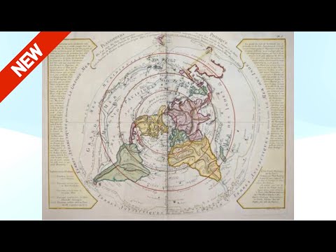
This map, the Physical Planisphere, by Phillipe Buache and the French Academy of Sciences is from 1762. While some parts of Australia and New Zealand are still not fully mapped, as well as the places on Antarctica that we see on the Gleason’s AE map, it does map the mountain ranges, underwater mountain ranges and currents, the major rivers and the major “height of land” water inclinations for all of the earth. It even shows rivers that disappear into the earth. The routes taken by famous French explorers are mapped as well along with the year of their expedition.
Remember to make sure to set the resolution as high as you can for your device, you can always pause to have a better look on the video. Also, depending on what device you’re using you may be able to pause and zoom by double tapping on a tablet or phone, or by pinch zooming.
The other map that’s discussed in this video will be featured in my next vid.
Thank you for watching,
Yah bless you.